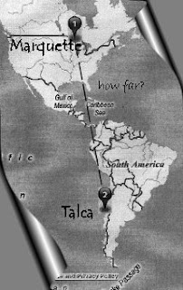
I am torn today between wanting to write about things passing (weather, burritos, moods) and this wave I got caught up in while thinking about my nephew in Talca, Chile. I wondered: How many miles between Marquette, Michigan, and Talca, Chile?
I asked Google and Ask.com, which mostly brought up stuff about Marquette and Talca and Catholicism. Yahoo Maps "could not calculate directions," so I gave maps.ask.com a shot. This bogged down the computer, so I went into the other room and pulled out my hefty Rand McNally Cosmopolitan World Atlas, New Census Edition, 1981. On pages 2-3 there is a map of the world, which I thought might be helpful, until I got distracted by this statement:
I asked Google and Ask.com, which mostly brought up stuff about Marquette and Talca and Catholicism. Yahoo Maps "could not calculate directions," so I gave maps.ask.com a shot. This bogged down the computer, so I went into the other room and pulled out my hefty Rand McNally Cosmopolitan World Atlas, New Census Edition, 1981. On pages 2-3 there is a map of the world, which I thought might be helpful, until I got distracted by this statement:
Antarctica has no legal time.
What does that mean?
The map was titled Comparative World Time (Legal Clock Time), and if I knew what time it was when I was doing all this, I would tell you. But think about it: Antarctica has no legal time. Does that mean it has no time? Does it have illegal time? What time is it, then, in Antarctica? Any time? No time? All the time? Some time? Has Antarctica lost track of time? Can one ever be late in Antarctica? Can one ever be early? And when the alarm clock goes off, what time is it? If it seems way too early, can one just set the clock back? How might one define the concept of "illegal time"? I did not pursue these questions on the web, as I much prefer just to think about these things, the fact that there is no legal time in Antarctica, and how that surely says something about time overall.
For some reason, the fact that there is no legal time in Antarctica made it impossible for me to figure out the mileage between Marquette, Michigan, and Talca, Chile, by using this tome of an atlas, so I returned to the computer. Much to my surprise, there was all the information I needed - maps.ask.com had come up with driving directions. Lo and behold, the 8,653.6-mile trip would take me 156 hours, 22 minutes, and 52 seconds (no mention if that included bathroom time), and on the way I would see Mexico, Guatemala, El Salvador, Honduras, Nicaragua, Costa Rica, Panama, Colombia, Ecuador, and Peru. I would travel on a good number of local roads, following directions such as "Bear RIGHT (West) onto Local road(s)," which I imagine as being quite dusty and picturesque with burros and squat stucco buildings and brightly colored rugs and shirts and flowers as big as my face and dark brown sandals. Without a doubt I would get lost, turned around, have adventures, and when I asked for directions I would explain how I didn't know if it's one road or two that I'm looking for, but see (I turn to Page 4 of my directions), I'm right here (I point), Direction #147, bear right onto local road(s) ...
Wouldn't it be marvelous if one could actually take such a trip without any fears? If one could cross borders and time zones and history and culture and experience another's world without judgment? Perhaps one can. I don't know. I stay home.
It's that time of year for baseball but snow, flowers but grey, spring but cold. A biting wind, an inky river, a silvery sky. Tomorrow might be sunny, but today is the kind of day one might spend wondering who is in Antarctica and why, and how do they set their clocks? Do they even have clocks? If so, why? Can't they just decide amongst themselves that it's now, say, 3 p.m., and go from there? Let's eat?
As my mother always says: This, too, shall pass.
The Talca Two


