
With a little thought, I would have realized it was too early to go out on the Tyoga trail, but my mind was all a-jumble with signs of spring, including a number of days without snow, quite a bit of sunshine, temperatures nipping at the 60-degree mark, finding one of Buster's long-missing winter booties on the morning trail, fuzzy buddies on the beech trees, and, to cap it all off, a "Peeper Report" on the evening news. Peepers (small frogs with big voices) had been heard over in Daggett. This can only mean spring, so out I headed to one of my favorite spots, the Tyoga Historical Pathway.
The Tyoga trail, as I call it, is a 1.4-mile hiking trail a couple of miles north of M-28, just off a dirt road that eventually leads to a boat launch on Lake Superior. The trail runs alongside the Laughing Whitefish River, crossing it once and then back again as it loops around the town of Tyoga, a town no longer there, a town which flourished briefly about 100 years ago, a town built around a sawmill built in the midst of about 7,000 acres of virgin timber that included hemlock, pine, and hardwoods, a town nearly forgotten until someone got wind of its story, mapped out the location, and brought Tyoga's tale back to life via brief vignettes and old photographs displayed on trailside plaques. If not for the plaques, it would be hard to believe a town once existed here. The woods are dense, the marshes are sudden, and the boulders are steep and craggy.
In winter, the trail is inaccessible as the road leading to it is mostly unplowed. In summer, the woods can be unbearably buggy. But in autumn, the trail is exquisite, alive with color and scent and mysterious light. In spring, it's merely a chance, for there are other, more prosaic signs of spring, such as deep snow lurking in the shadows and melting snow giving rise to surging rivers, squishy swamps, complacent ponds, and sneaky streams. All wet, all cold. These are the signs I quickly recalled as I headed down the Tyoga trail.
The trail starts off hugging the west bank of the river. Due to a high level of tannin, the Laughing Whitefish is murky as tea, and this morning apparently high on caffeine. The river was frolicking and kicking up its heels in the bright sunshine, dancing over fallen branches and skipping over stones, tumbling and twirling to its own music. At first the trail was clear, but it wasn't long before I was walking in knee-deep snow. The bridge was just ahead, maybe on the other side ...
Still deep snow. But it lessened as the trail turned away from the river and climbed into the woods, where melted snow ran in gurgling streams and pooled between hillocks and roots and boulders, doing its best to submerge my path. Add in the winter's windfall of trees, including one huge white cedar that had once stood trailside but now lay broken across the trail, and you're looking at one path that's hard to follow.
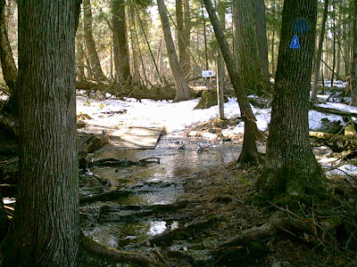
But the Tyoga trail is often hard to follow. Even on the nicest of days I have had to stop and look for the blue blazes painted on the trees, marking which direction to go. It is never a very wide trail, and often it seems to be nothing more than a lightly chiseled groove, a hesitant suggestion, a scarecrow flopping its arm this way, or maybe that way. But I have walked the trail a number of times now, and I'm beginning to know its twists and turns and to recognize when a change in terrain is due. This first part, where I was now, could be some of the toughest, as the trail scrambles up and down boulders, skips over streams, and wrangles its way through rascally roots. But I was just about through it, skirting the obstacles, keeping an eye out for blue-splotched trees, and now at the point where the woods fell back a little bit, opened up a little bit, and the earth turned to meadow.
A swamp up ahead. I felt sure the trail was under there somewhere; I could hop from one hummock to another; maybe that would work. I looked for a trail marker, came up empty.
Where in blue blazes was I?
I backed up to my last marker, sensed the direction I should go (the swamp) and hopped ahead a bit, looking for a splotch or a plaque. Nothing. Suddenly, I felt something moving swiftly toward me. I froze. I turned my head slightly and caught sight of a deer bounding in my direction. He froze, stopping about 20 yards from me. He looked around cautiously, looking for me, I presumed. Eventually he turned, but stayed hesitant. I admired his black and white trimmed ears and tail, his incredibly knock-kneed hind legs. He took off, away from me, and I realized my feet were soaking wet and cold and I'd somehow run out of blue blazes. I decided to call it a day.
The Tyoga trail runs clockwise, and I was now countering it, having to check behind me for the blazes. I'd just been by this way, hadn't walked very far, you might think it would be easier, heading back, but it wasn't. At one point I stopped, dumbfounded. I wasn't lost - there was that downed white cedar just behind me - but I could not find the trail or the next blue blaze, and the way I thought I should go wasn't turning out right. I backtracked once again and stood still. Aha. There's the way.
Soon I was walking in my own footsteps in the knee-deep snow. Near the start of the trail is a small sandy area along the riverbank, across from the three-story sawmill that no longer exists, not even a whisper. The spot was bathed in sunlight. I sat down and loosened my soggy boots. The river sang, and I smiled. Tyoga would have to wait for another day.
Tyoga Trail: Part Two
Tyoga Trail: Part Three
The Tyoga trail, as I call it, is a 1.4-mile hiking trail a couple of miles north of M-28, just off a dirt road that eventually leads to a boat launch on Lake Superior. The trail runs alongside the Laughing Whitefish River, crossing it once and then back again as it loops around the town of Tyoga, a town no longer there, a town which flourished briefly about 100 years ago, a town built around a sawmill built in the midst of about 7,000 acres of virgin timber that included hemlock, pine, and hardwoods, a town nearly forgotten until someone got wind of its story, mapped out the location, and brought Tyoga's tale back to life via brief vignettes and old photographs displayed on trailside plaques. If not for the plaques, it would be hard to believe a town once existed here. The woods are dense, the marshes are sudden, and the boulders are steep and craggy.
In winter, the trail is inaccessible as the road leading to it is mostly unplowed. In summer, the woods can be unbearably buggy. But in autumn, the trail is exquisite, alive with color and scent and mysterious light. In spring, it's merely a chance, for there are other, more prosaic signs of spring, such as deep snow lurking in the shadows and melting snow giving rise to surging rivers, squishy swamps, complacent ponds, and sneaky streams. All wet, all cold. These are the signs I quickly recalled as I headed down the Tyoga trail.
The trail starts off hugging the west bank of the river. Due to a high level of tannin, the Laughing Whitefish is murky as tea, and this morning apparently high on caffeine. The river was frolicking and kicking up its heels in the bright sunshine, dancing over fallen branches and skipping over stones, tumbling and twirling to its own music. At first the trail was clear, but it wasn't long before I was walking in knee-deep snow. The bridge was just ahead, maybe on the other side ...
Still deep snow. But it lessened as the trail turned away from the river and climbed into the woods, where melted snow ran in gurgling streams and pooled between hillocks and roots and boulders, doing its best to submerge my path. Add in the winter's windfall of trees, including one huge white cedar that had once stood trailside but now lay broken across the trail, and you're looking at one path that's hard to follow.
But the Tyoga trail is often hard to follow. Even on the nicest of days I have had to stop and look for the blue blazes painted on the trees, marking which direction to go. It is never a very wide trail, and often it seems to be nothing more than a lightly chiseled groove, a hesitant suggestion, a scarecrow flopping its arm this way, or maybe that way. But I have walked the trail a number of times now, and I'm beginning to know its twists and turns and to recognize when a change in terrain is due. This first part, where I was now, could be some of the toughest, as the trail scrambles up and down boulders, skips over streams, and wrangles its way through rascally roots. But I was just about through it, skirting the obstacles, keeping an eye out for blue-splotched trees, and now at the point where the woods fell back a little bit, opened up a little bit, and the earth turned to meadow.
A swamp up ahead. I felt sure the trail was under there somewhere; I could hop from one hummock to another; maybe that would work. I looked for a trail marker, came up empty.
Where in blue blazes was I?
I backed up to my last marker, sensed the direction I should go (the swamp) and hopped ahead a bit, looking for a splotch or a plaque. Nothing. Suddenly, I felt something moving swiftly toward me. I froze. I turned my head slightly and caught sight of a deer bounding in my direction. He froze, stopping about 20 yards from me. He looked around cautiously, looking for me, I presumed. Eventually he turned, but stayed hesitant. I admired his black and white trimmed ears and tail, his incredibly knock-kneed hind legs. He took off, away from me, and I realized my feet were soaking wet and cold and I'd somehow run out of blue blazes. I decided to call it a day.
The Tyoga trail runs clockwise, and I was now countering it, having to check behind me for the blazes. I'd just been by this way, hadn't walked very far, you might think it would be easier, heading back, but it wasn't. At one point I stopped, dumbfounded. I wasn't lost - there was that downed white cedar just behind me - but I could not find the trail or the next blue blaze, and the way I thought I should go wasn't turning out right. I backtracked once again and stood still. Aha. There's the way.
Soon I was walking in my own footsteps in the knee-deep snow. Near the start of the trail is a small sandy area along the riverbank, across from the three-story sawmill that no longer exists, not even a whisper. The spot was bathed in sunlight. I sat down and loosened my soggy boots. The river sang, and I smiled. Tyoga would have to wait for another day.
Tyoga Trail: Part Two
Tyoga Trail: Part Three